Berkas:1815 tambora explosion.png

Tu'udu lo'u diipo mopobilohu: 800 x 358 piksel resolusi uweewo:320 x 143 piksel | 640 x 286 piksel | 1.200 x 537 piksel
Berkas asli (1.200 x 537 piksel, tu'udu berkas:720 KB, MIME tipe: image/png)
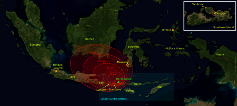
| Deskripsi | The 1815 Mount Tambora eruption. The red areas are maps of the thickness of volcanic ashfall. | ||||||||
| Bungo | The base map was taken from NASA picture Image:Indonesia_BMNG.png and the isopach maps were traced from Oppenheimer (2003).[1] | ||||||||
| Ta ohu'uwo | myself | ||||||||
| Ijini (Popohunawa ulangi berkas botiye) |
|
||||||||
| Versi lainnya |
Deutsch: Von diesem Bild existieren die folgenden Bildbearbeitungen aus der Bilderwerkstatt: English: Retouched versions of this picture from the german Graphic Lab:
|

References
- ↑ Oppenheimer, Clive (2003). "Climatic, environmental and human consequences of the largest known historic eruption: Tambora volcano (Indonesia) 1815". Progress in Physical Geography 27 (2): 230-259.
Riwāyati lo berkas
Klik to tanggal/wakutu momilohe berkas to saa'ati botiye.
| Tanggal/Wakutu | Gambari kiki'o | Dimensi | Ta ohu'uwo | Lo'iya | |
|---|---|---|---|---|---|
| baharu | 11 Oktober 2006 21.14 | | 1.200 × 537 (720 KB) | Indon~commonswiki | {{Information |Description= The 1815 Mount Tambora eruption. The red areas are maps of the thickness of vulcanic ashfall. |Source=The base map was taken from NASA picture Image:Indonesia_BMNG.png and the isopach maps were traced |
| 11 Oktober 2006 21.12 |  | 1.200 × 537 (720 KB) | Indon~commonswiki | ||
| 11 Oktober 2006 20.50 |  | 1.200 × 537 (686 KB) | Indon~commonswiki | {{Information |Description= The 1815 Mount Tambora eruption. The red areas are w:isopach maps of the density of fallen vulcanic ashes. |Source=The base map was taken from NASA picture Image:Indonesia_BMNG.png and the isopach |
Berkas u pilopohuna
Halaman botiya lopohuna berkas:
Pilopohuna berkas global
Wiki uweewo hemomake berkas botiya
- Pilopohuna to ar.wikipedia.org
- Pilopohuna to ast.wikipedia.org
- Pilopohuna to be-tarask.wikipedia.org
- Pilopohuna to ca.wikipedia.org
- Pilopohuna to de.wikipedia.org
- Pilopohuna to en.wikipedia.org
- Pilopohuna to es.wikipedia.org
- Pilopohuna to id.wikipedia.org
- Pilopohuna to lt.wikipedia.org
- Pilopohuna to ms.wikipedia.org
- Pilopohuna to ro.wikipedia.org
- Pilopohuna to sh.wikipedia.org
- Pilopohuna to sv.wikipedia.org
- Pilopohuna to th.wikipedia.org
- Pilopohuna to tr.wikipedia.org